
What Are The Benefits Of Using GIS Technology For Creating Section Maps In ESRI?
You can harness the power of Geographic Information System (GIS) technology to create accurate and detailed section maps in ESRI. By utilizing GIS tools, you…
You can harness the power of Geographic Information System (GIS) technology to create accurate and detailed section maps in ESRI. By utilizing GIS tools, you…

When considering understanding property boundaries and divisions, ESRI’s Plat Maps are an invaluable tool for homeowners, real estate professionals, and land surveyors alike. These detailed…

With ESRI’s topographic mapping tools, understanding and analyzing terrain features and elevation levels becomes an efficient and insightful process. These tools provide detailed data and…

Boundaries are crucial elements when it comes to identifying property ownership and understanding land demarcations. ESRI mapping offers a powerful tool for individuals and organizations…

It’s fascinating how technology allows us to explore into the past and explore the evolution of land ownership and boundaries over time. ESRI Historic Maps…
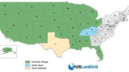
Introducing USLandGrid.com’s Revolutionary Version 10.0 National Land Grid, Delivering Unparalleled Land Mapping Detail and Coverage USLandGrid proudly announces the release of version 10.0 of their…
Lot’s of companies need GIS solutions that are specific to their needs. USLandGrid supports the enterprise down to the desktop with extensive experience in web mapping and custom tools.

Top-Ranked Technology Delivers Secure, Scalable Spatial Analysis in Era of Big Data and Digital Transformation REDLANDS, Calif.—December 19, 2016—Esri, the global leader in spatial analytics…

GIS is a skilled profession in which answers to problems can be solved by using spatial and physical relationships based on collected statistics and data….

Recently at Pipeline Week Oil and Gas Space got the chance to catch up with the new president of Novara GeoSolutions, Neal O’Driscoll, to discuss…