
Over time, the significance of geospatial granularity in well site assessments has become increasingly evident. By harnessing detailed geographic information, you can enhance your decision-making processes, mitigate risks, and optimize resource allocation. Understanding the varying levels of geospatial data allows you to make informed assessments and tailor your strategies to the unique characteristics of each site. In this blog post, you will explore how elevated levels of detail in geospatial data can impact your assessments and ultimately lead to more efficient site evaluations.
Geospatial Granularity Defined
For effective well site assessments, understanding geospatial granularity is imperative. This concept refers to the level of detail at which geographic data is collected and analyzed. Higher granularity means more precise data points, allowing for better decision-making during environmental evaluations.
What is Geospatial Granularity?
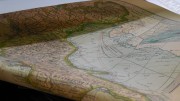
On a fundamental level, geospatial granularity refers to the resolution of spatial data. It can range from broad, regional scales with limited detail to finer, local scales that provide intricate insights into specific areas. This range significantly affects the accuracy and reliability of assessments.
Importance in Environmental Assessments
With higher geospatial granularity, you can achieve more accurate and detailed environmental assessments. The fine details allow you to identify potential risks and opportunities more effectively, ultimately enhancing your planning and operational strategies.
A thorough understanding of geospatial granularity empowers you to make informed decisions based on precise data. By utilizing more granular information, you can pinpoint specific environmental factors related to well sites, like soil composition, water sources, and ecological habitats. This level of detail not only aids in risk mitigation but also fosters compliance with environmental regulations, enhancing your overall operational efficiency.
Current Practices in Well Site Assessments
You may find that well site assessments typically involve a variety of traditional methods that have been used for years. These assessments often rely on geological surveys, environmental evaluations, and manual data collection to make decisions about site viability. However, the effectiveness of these methods can vary, and advancements in technology now present new opportunities for improvement.
Traditional Assessment Methods
Site evaluations commonly involve physical inspections and the interpretation of subsurface data through drilling logs and geological mapping. These methods provide a foundational understanding of the area but often depend on outdated data and may overlook important spatial factors that influence site suitability.
Limitations of Existing Approaches
Approaches like manual data collection and traditional surveying are often limited in scope and can be time-consuming, leading to delays in project timelines. Additionally, they may lack the granularity needed to capture spatial variations that significantly affect site assessment outcomes.
Due to the constraints of conventional methods, existing assessments may overlook critical site conditions, resulting in incomplete analyses and potential risks. For example, variations in soil types, hydrology, and surrounding land use may not be adequately represented, leading to unforeseen challenges during development. This highlights the need for more sophisticated assessment techniques that integrate geospatial data for a comprehensive understanding of well site conditions.
Enhancing Assessment Accuracy with Geospatial Granularity
Clearly, the integration of geospatial granularity significantly improves the precision of well site assessments. By examining data at finer spatial resolutions, you attain a clearer perspective of geographic features and potential resource distributions. Enhanced granularity not only helps identify optimal drilling locations but also minimizes risks associated with environmental impact and resource management. This focused approach ensures more informed decision-making and drives efficient operations in the field.
Data Collection Techniques
One effective way to gather valuable geospatial data is through advanced survey techniques, including remote sensing and geophysical surveys. Utilizing high-resolution satellite imagery, LiDAR, and geographic information systems (GIS) allows you to collect detailed information about the terrain, subsurface features, and existing infrastructure. These methods enhance the quality of the data you analyze, helping you to create more accurate and detailed site assessments.
Analytical Tools and Technologies
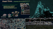
Below, a variety of analytical tools and technologies facilitate the interpretation of geospatial data. You can utilize GIS software, which provides robust functionalities for analyzing spatial relationships and patterns. Moreover, machine learning algorithms can help refine your predictions based on historical data, while real-time data processing creates dynamic models for current site conditions.
It is crucial to choose the right analytical tools and technologies to maximize your well site assessment accuracy. By employing software such as GIS and employing machine learning, you can uncover hidden patterns in the data that traditional methods may overlook. Real-time processing capabilities further enhance your analysis, allowing for quicker decision-making based on current conditions. Leveraging these advanced technologies not only streamlines the assessment process but also enhances your ability to adapt to changing circumstances in the field.
Case Studies: Successful Applications
Once again, various organizations have demonstrated the effectiveness of geospatial granularity in enhancing well site assessments. Here are some notable case studies:
- Case Study 1: XYZ Corp utilized high-resolution satellite imagery to reduce site selection time by 30%, leading to a 25% increase in production.
- Case Study 2: ABC Energy implemented drone surveys, improving the accuracy of geological assessments by 40% and decreasing risk by 20%.
- Case Study 3: 123 Resources integrated real-time geospatial data, resulting in a 15% operational cost reduction while boosting resource recovery efficiency by 10%.
Review of Real-World Examples
One can see the profound impact of geospatial granularity in these real-world examples. Each case not only validated the technology’s effectiveness but also highlighted the practical benefits that enhance overall project outcomes. By optimizing site assessments through advanced geospatial techniques, organizations were able to make informed decisions that led to increased efficiency and reduced risk.
Lessons Learned from Implementation
At the heart of these successful applications are valuable lessons that can guide your future endeavors. Understanding the importance of tailored geospatial strategies specific to each well site can significantly improve project viability and economic outcomes.
Learned from these implementations is the necessity of aligning your geospatial data collection methods with your project objectives. Investments in high-resolution imaging and real-time monitoring technologies yield substantial returns in accuracy and efficiency. Furthermore, fostering collaboration between geologists, engineers, and data scientists ensures that your assessments are comprehensive, leveraging diverse expertise for optimal decision-making. By integrating these lessons, you can enhance your site assessments and drive successful project results.
Challenges and Considerations
Unlike conventional assessments, enhancing geospatial granularity can introduce complexities that may impede overall effectiveness. These challenges often involve navigating significant volumes of data, necessitating advanced analytical tools and skilled personnel to interpret results accurately. You must also consider the integration of various data sources, which may lead to inconsistencies or errors if not managed carefully. Overall, these factors may complicate your site assessment efforts, requiring a strategic approach to mitigate potential issues while maximizing the advantages of granular geospatial insights.
Technical and Operational Barriers
Considerations for implementing geospatial granularity include the technical expertise required to utilize sophisticated software and the operational adjustments needed to integrate new data methodologies. You may face limitations such as inadequate infrastructure or insufficient training for personnel, which could hinder effective data analysis and application.
Cost-Benefit Analysis
By evaluating the financial implications of adopting geospatial granularity, you can determine whether the potential benefits justify the expenses involved. Implementing advanced data tools may require a significant initial investment, but improved decision-making capabilities could lead to long-term savings and enhanced operational efficiency.
With a thorough cost-benefit analysis, you can assess both short-term expenses and long-term returns on investment by improving well site assessments. Consider factors like increased accuracy in site selection and reduced risks, as these may translate into fewer operational disruptions and more productive outcomes. Evaluating these dimensions will enable you to make informed decisions about adopting geospatial approaches tailored to your specific needs and objectives.
Future Directions in Geospatial Assessments
Now is the time to embrace advanced geospatial technologies that promise to enhance your well site assessments significantly. As the energy industry evolves, integrating real-time data with refined granularity will enable you to make more informed decisions. The incorporation of machine learning and artificial intelligence in geospatial analyses offers a pathway towards optimizing exploration activities, ultimately improving efficiency and reducing risks.
Emerging Trends and Innovations
Emerging technologies such as drone surveying, 3D modeling, and satellite imagery are revolutionizing how you conduct geospatial assessments. These innovations facilitate a comprehensive understanding of well site dynamics by offering high-resolution data and real-time analytics. By leveraging these advancements, you can enhance your decision-making processes and improve project outcomes significantly.
Recommendations for Best Practices
Above all, establishing a systematic approach to geospatial assessments is vital for achieving optimal results. Regular training on the latest tools and methodologies is key to ensuring that you remain at the forefront of industry innovations. Furthermore, fostering collaboration between geospatial analysts, environmental scientists, and project managers can significantly enhance the accuracy and reliability of your assessments.
Also, integrating continuous feedback loops into your workflow can yield substantial improvements in data quality and relevance. Establishing standards for data collection and analysis will help to maintain consistency across your assessments. Additionally, utilizing interdisciplinary teams to interpret geospatial information ensures diverse perspectives and enhances the overall assessment quality. Ultimately, these best practices will position you to maximize the benefits of enhanced geospatial granularity in your well site evaluations.
Summing up
On the whole, understanding the extent to which geospatial granularity can enhance your well site assessments is crucial for informed decision-making. By utilizing finer levels of spatial detail, you can gain deeper insights into site characteristics, hydrology, and potential environmental impacts. This precision not only aids in optimizing resource allocation but also mitigates risks, leading to more sustainable operations. Ultimately, adopting advanced geospatial strategies allows you to leverage detailed data for improved performance in your well site evaluations.

Be the first to comment on "To What Extent Can Geospatial Granularity Improve Well Site Assessments?"