
What Are The Benefits Of Using GIS Technology For Creating Section Maps In ESRI?
You can harness the power of Geographic Information System (GIS) technology to create accurate and detailed section maps in ESRI. By utilizing GIS tools, you…
You can harness the power of Geographic Information System (GIS) technology to create accurate and detailed section maps in ESRI. By utilizing GIS tools, you…

When considering understanding property boundaries and divisions, ESRI’s Plat Maps are an invaluable tool for homeowners, real estate professionals, and land surveyors alike. These detailed…

With ESRI’s topographic mapping tools, understanding and analyzing terrain features and elevation levels becomes an efficient and insightful process. These tools provide detailed data and…

Boundaries are crucial elements when it comes to identifying property ownership and understanding land demarcations. ESRI mapping offers a powerful tool for individuals and organizations…

It’s fascinating how technology allows us to explore into the past and explore the evolution of land ownership and boundaries over time. ESRI Historic Maps…
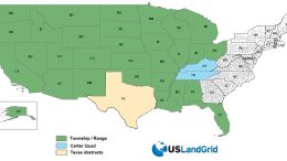
Introducing USLandGrid.com’s Revolutionary Version 10.0 National Land Grid, Delivering Unparalleled Land Mapping Detail and Coverage USLandGrid proudly announces the release of version 10.0 of their…