Most parcel mapping processes can benefit significantly from GIS digitizing, enhancing both precision and reliability in spatial data representation. By employing advanced GIS technology, you can accurately capture, analyze, and visualize land parcel information, resulting in improved decision-making. This method allows for the integration of various data sources, reducing errors associated with traditional mapping methods and ensuring your land records maintain their integrity over time. Ultimately, leveraging GIS in your mapping efforts leads to a more efficient and accurate understanding of property boundaries and land use.
The Technical Revolution in Parcel Mapping
The shift from traditional mapping methods to modern GIS technology has transformed how you approach parcel mapping. Enhanced by digital tools, the accuracy and efficiency of mapping processes have drastically improved, enabling you to capture more detailed and precise property boundaries. This revolution allows for better planning, decision-making, and management of real estate assets, fostering a more streamlined workflow in your projects.
Transitioning from Paper to Digital
Embracing GIS for parcel mapping marks a significant transition from paper-based systems, which often suffer from inaccuracies and time-consuming updates. Digital formats allow you to easily modify, update, and share mapping data, enhancing collaboration and significantly reducing the time spent on mapping revisions. This shift not only improves precision but also increases accessibility to vital information.
Innovations in GIS Technology
New developments in GIS technology have introduced advanced tools such as machine learning and 3D modeling, which refine how you visualize and analyze parcel data. These innovations provide insights that were previously unattainable, allowing for more informed decision-making. The integration of real-time data feeds also enhances your ability to respond to changes in land use and zoning regulations swiftly.
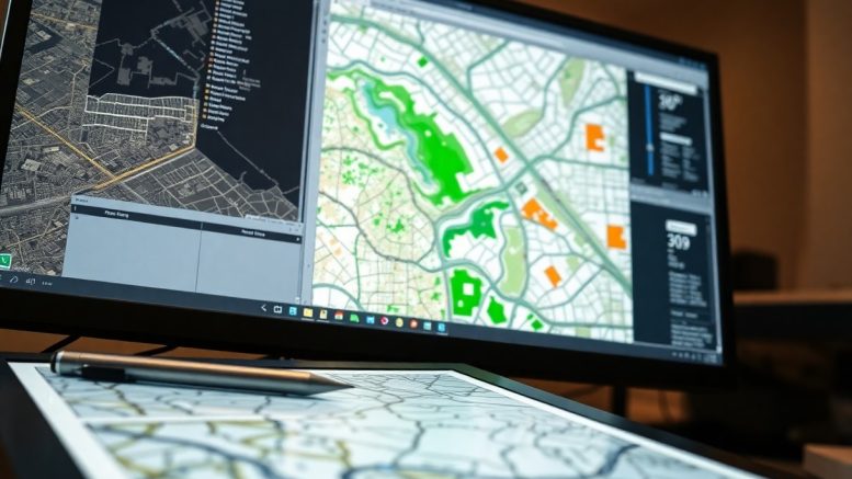
For instance, recent advancements such as drone-based aerial surveys significantly reduce manual labor while capturing high-resolution imagery. Through automated image analysis, you can quickly identify changes in land use or encroachments on property lines. Additionally, cloud-based GIS platforms facilitate real-time collaboration among stakeholders, ensuring that everyone involved has access to the most current maps and data. This not only enhances accuracy but also streamlines the entire parcel mapping process, enabling you to manage projects more effectively than ever before.
Precision Perfected: How GIS Enhances Data Accuracy
Through advanced technology, GIS significantly boosts data accuracy in parcel mapping. With precise tools and methodologies, you can eliminate inconsistencies and enhance the quality of your spatial information. This level of precision minimizes ambiguity, providing a solid foundation for effective decision-making in land use planning and property management.
Georeferencing and Coordinate Systems
Georeferencing aligns spatial data to a defined coordinate system, ensuring your map layers correspond accurately to real-world locations. By integrating data from various sources, you can achieve a unified framework that transcends discrepancies, enabling you to visualize and analyze parcel data with confidence.
Error Reduction Techniques
Utilizing robust error reduction techniques helps maintain the integrity of your data. Techniques such as data validation, automated checks, and advanced algorithms identify anomalies, allowing you to rectify errors before they propagate through your mapping processes.
Error reduction techniques in GIS can include automated data validation, where algorithms check for inconsistencies and anomalies in datasets, pinpointing errors before they can impact the analysis. Regular updates and maintenance ensure that your datasets remain accurate over time. Incorporating user feedback also allows for real-world insights to enhance data quality. For instance, using crowdsourced information can validate location accuracy and identify missing or incorrectly mapped parcels, greatly improving reliability and trust in your mapping efforts.
The Art of Visualization: Making Complex Data Accessible
Effective visualization transforms intricate data sets into understandable formats, empowering users to make informed decisions. By utilizing maps, charts, and other visual tools, GIS allows you to quickly grasp critical spatial relationships and patterns in parcel mapping. This accessibility not only helps in identifying trends but also enhances the communication of complex data to stakeholders, ensuring everyone involved can see and understand the key insights without technical expertise.
User-Friendly Mapping Interfaces
User-friendly mapping interfaces simplify your interaction with GIS data. Intuitive design elements such as drag-and-drop functionality, streamlined menus, and customizable layers allow you to navigate complex information effortlessly. This ease of use means you can focus on analyzing spatial data and making decisions without getting bogged down by technical hurdles.
Interactive Features that Engage Stakeholders
Interactive features foster a collaborative environment among stakeholders in your parcel mapping projects. Tools such as clickable maps, filtering options, and real-time data updates create an immersive experience. These functionalities encourage active participation, enabling stakeholders to explore and interact with the data firsthand, leading to more effective discussions and decision-making.
Stakeholders can dive deep into specific parcels, assessing attributes and making comparisons thanks to interactive features. For instance, a clickable map may reveal property boundaries, land use, or zoning information, allowing different users, including planners and developers, to visualize their interests. Features like pop-up data summaries or layer toggles elevate engagement, urging stakeholders to offer input or raise questions based on what they see. Such collaboration fosters a unified vision for projects, reducing misunderstandings and streamlining processes.
Real-World Applications: Transforming Parcel Management
Applying GIS digitizing in real-world parcel management has reshaped how organizations oversee land use, streamline operations, and enhance overall spatial decision-making. By integrating accurate and up-to-date mapping data, municipalities and private entities can make informed choices that align with zoning regulations, property assessments, and community development goals.
Enhancing Urban Planning and Development
You can leverage GIS technology to improve urban planning and development initiatives significantly. By creating layers of information, such as demographics, infrastructure, and environmental factors, planners can visualize potential developments’ impact and align them with community needs and regulatory frameworks.
Improving Land Use Efficiency
GIS plays a pivotal role in optimizing land use, enabling planners to efficiently allocate resources and determine suitable applications for various parcels. This enhances sustainability and maximizes economic growth by offering actionable insights for strategic developments.
Implementing GIS in land use planning allows for a detailed analysis of current utilization patterns. This analytical approach enables you to identify underused spaces or parcels ripe for redevelopment, facilitating more sustainable land utilization. A case in point is the City of Portland, Oregon, which implemented GIS to analyze land use trends and created a comprehensive planning strategy that resulted in a 15% increase in effective land use within just five years. By evaluating factors like accessibility, infrastructure, and environmental impact, GIS empowers you to make informed decisions supporting efficient land development and reducing urban sprawl.
The Future Landscape of Parcel Mapping: Trends and Predictions
The evolution of technology is shaping the future of parcel mapping, where real-time data and user-centric design will dominate. Innovations in drone technology and satellite imagery are increasing the integration of higher-resolution location data, streamlining the parcel mapping process. As the demand for accurate, timely information grows, systems will adapt to provide flexibility and responsiveness to your mapping needs, enhancing decision-making capabilities across various sectors.
Integration of AI and Machine Learning
AI and machine learning are set to revolutionize parcel mapping, enabling automated data analysis and anomaly detection. These technologies analyze vast datasets to identify patterns and predict outcomes, assisting you in making informed decisions faster. Machine learning algorithms can learn from historical parcel data, improving accuracy and efficiency in future mapping endeavors.
Preparing for Emerging Challenges and Opportunities
As technology advances, staying ahead of emerging challenges in parcel mapping requires strategic adaptations. The integration of diverse data sources will bring complexity, necessitating robust training for users. Advances in regulatory requirements, such as data privacy laws, will also shape how you manage and share parcel information. Embracing these changes presents opportunities to enhance collaboration and efficiency in development projects.
Preparing for emerging challenges involves actively engaging with evolving technologies and legislative landscapes. For instance, utilizing blockchain can enhance data security while facilitating transparent transactions in property dealings. Investing in ongoing education for GIS professionals ensures they remain adept at using new tools and methodologies. Greater collaboration between stakeholders in urban planning, environmental management, and real estate further fosters innovation, positioning you to leverage these shifts effectively in parcel mapping.
Summing up
Following this, you can see that GIS digitizing enhances accuracy in parcel mapping by allowing you to capture, analyze, and manage spatial data with precision. By employing advanced technology, you can reduce human error, streamline data collection processes, and ensure up-to-date information. This improvement leads to better decision-making and effective land management, empowering you to create more reliable and detailed parcel maps that meet your needs.


Be the first to comment on "How Does GIS Digitizing Improve Accuracy In Parcel Mapping?"