
Pipeline Open Data Standards – An Explanation of the Core Module
Anyone who has ever seen the schematic diagram located on the Pipeline Open Data Standards (PODS) website (www.pods.org) is directed to a brightly colored, categorized…
Anyone who has ever seen the schematic diagram located on the Pipeline Open Data Standards (PODS) website (www.pods.org) is directed to a brightly colored, categorized…
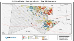
USLandGrid now provides drilling units across the United States. Delivered in shapefiles, the data is broken down by basin, top operators within the basin and…

SUNNYVALE, Calif., Aug. 20, 2015—100 Resilient Cities – Pioneered by the Rockefeller Foundation (100RC) is partnering with Trimble (NASDAQ: TRMB), which will offer a critical…
SUNNYVALE, Calif., Aug. 10, 2015—Trimble (NASDAQ: TRMB) announced today the launch of Trimble® VRS Now™ correction service in New Mexico. The commercial subscription service provides…
SUNNYVALE, Calif., Aug. 17, 2015—Trimble announced today the launch of Trimble® VRS Now™ correction service in Georgia. The commercial subscription service provides surveyors, civil engineers,…

The Pipeline Open Data Standard (PODS) database is designed to be a reporting tool for pipeline projects by creating a populated database of relevant information…

When it comes to general-purpose third party ArcGIS Desktop Extensions, two popular products stand out: ET GeoWizards and XTools Pro. ET GeoWizards is an ArcGIS…